About National Hurricane Center Data
Download the most comprehensive Hurricane Tracker app for iOS. MAIN FEATURES INCLUDE: + GOES Satellite Imagery Animations + National Hurricane Center Products + National Weather Service Alerts + Weather Predi
Download the most comprehensive Hurricane Tracker app for iOS.
MAIN FEATURES INCLUDE:
+ GOES Satellite Imagery Animations
+ National Hurricane Center Products
+ National Weather Service Alerts
+ Weather Prediction Center Graphics
+ Tropical Weather Push Notifications
+ Satellite Imagery Home Screen Widget
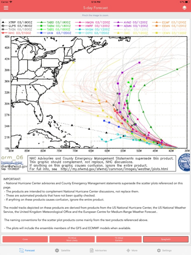
+ Spaghetti Models
GRAPHICAL PRODUCTS INCLUDE:
Forecast Graphics
- Spaghetti Models
- 7-Day Tropical Weather Outlook
- 3-Day Excessive Rainfall Outlook
- 7-Day Quantitative Precipitation Forecast
Storm Specific Graphics
- Key Messages
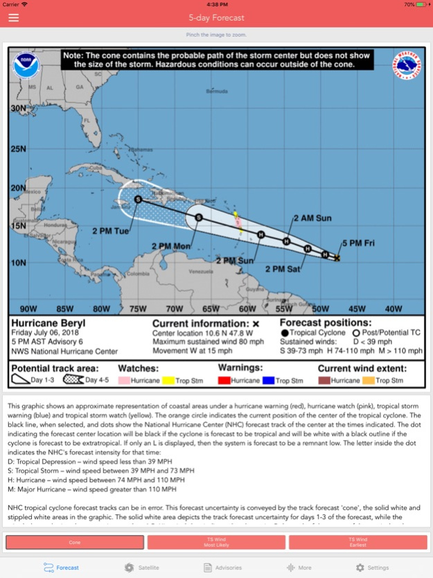
- Cone Track Forecast
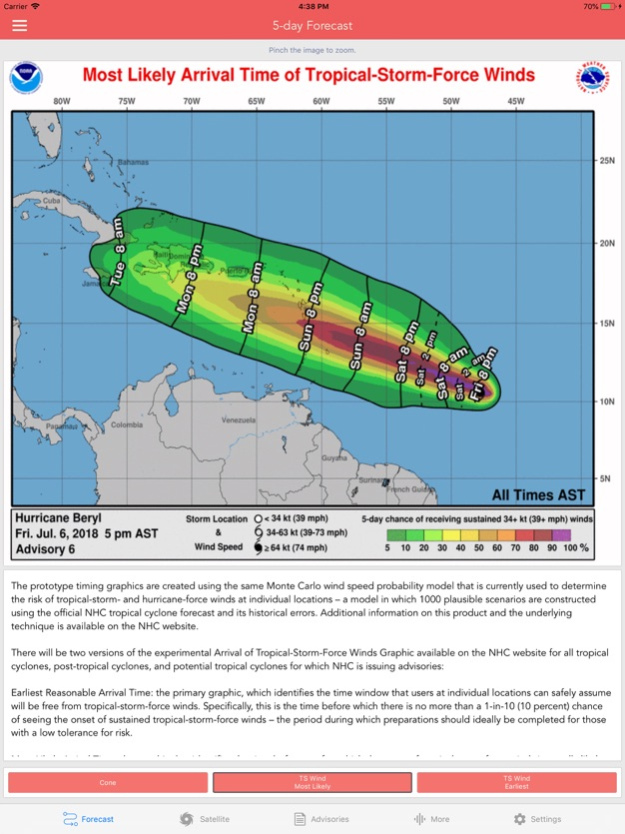
- Tropical Storm Wind (Most Likely)
- Tropical Storm Wind (Earliest)
- Hurricane Wind Probability
- Surface Wind Field
- Surface Wind Analysis
- Wind / Track History
- Rainfall Forecast
- Flash Flood Risk
Local Storm Threat Graphics
- Flooding Rain Threat
- Wind Threat
- Surge Threat
- Tornado Threat
- Rainfall Totals
- Wind Warnings
Note: Local threat graphics are typically not available until shortly before storm landfall.
TEXT PRODUCTS INCLUDE:
- Tropical Weather Outlook
- Forecast Advisories
- Public Advisories
- Forecast Office Discussion
- Local Statement (HLS)
- Local Warnings (TCV)
- Tropical Discussion
- Wind Analysis
WEATHER MAP OVERLAYS INCLUDE:
- Hurricane Track & Intensity
- Potential Storm Surge Flooding
- NASA Sea Surface Temperature
- NOAA Weather Radar
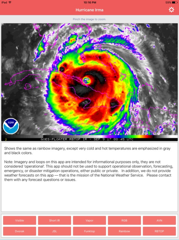
GOES SATELLITE IMAGERY INCLUDES:
Fifteen (15) Satellite Imagery Filters
- Visible (Band 2)
- Near IR (Bands 4 & 5)
- Infrared (Bands 7, 8, 9, 10, 13, 14 & 16)
- Nighttime Microphysics
- Day Cloud Phase
- True Color
- Air Mass
- Sandwich
APPLE WATCH APP INCLUDES:
- View wind speed & intensity updates every 30 minutes
- View the latest satellite imagery
- Choose from a variety of Watch Complications
-- PRO SUBSCRIPTION FEATURES --
Full Screen, High Resolution Satellite Imagery:
- Latest Image
- Animated Loop
- Mesoscale: Near Real-time Imagery
- Geostationary Lightning Mapper (GLM)
Mesoscale imagery typically has 1-minute temporal resolution, but is not always available for each storm.
16-day Weather Forecast Models:
- Global Forecast System (GFS)
- Global Ensemble Forecast System (GEFS)
- North American Ensemble (NAEFS)
Weather Simulation Forecast Models:
- Hi-Res Rapid Refresh (HRRR)
- Hi-Res Ensemble Forecast (HREF)
- North American Mesoscale (NAM)
- Hi-Res North American Mesoscale
(NAM-HIRES)
- High Resolution Window
(HRW-FV3, HRW-ARW, HRW-ARW2)
- WaveWatch III (WW3)
- European Centre for Medium-Range Weather
(ECMWF)
HMON & HWRF Hurricane Forecast Models
Experimental Forecast Animations:
- Simulated Radar 2km
- Surface Pressure, Wind
- 200mb Temp, Ht, Wind
- 700mb RH, Ht, Wind
- 850mb Vort, Wind, Thick
Model Analysis & Guidance Animations:
- 6h Total Precipitation
- 10m Wind
- 200mb Vort, Wind, Ht
- 500mb Relative Humidity
- 700mb Vort, Wind, Ht
- 850mb Vort, Wind, Ht
Static Forecast Products
- Track*
- Intensity*
- Pressure*
- Rain
- Wind
* Track, Intensity and Pressure graphics include spaghetti plots when available. Models included in spaghetti graphics include: HWRF, HMON, CTCX, AVNO, SHF5 & OFCL.
NCEP / EMC Cyclogenesis Tracking Products
- 16-day Storm Forecast Tracks
- 21-day Global Tropics Hazards Outlook
- 35-day Probability of Formation
CIMSS Tropical Cyclone Products
- Wind Vorticity & Shear Analysis
- Steering Layer Analysis
- Morphed Integrated Microwave Imagery
- Advanced Dvorak Technique (ADTV9.0)
ADT Includes imagery, wind radii estimates & trends
Interactive Hurricane Tracker Map
- Track & Intensity Forecast
- Preliminary Best Track Analysis
TERMS & CONDITIONS
https://lwbrandsllc.com/hurricane-app-terms-conditions/
--
In total, there are now over 100+ hurricane / weather tracking products to help you stay informed during hurricane season.
Mar 29, 2024
Version 1.37
+ Fixed a few minor bugs
Previous Updates Include:
+ New Apple Watch app
+ New NASA Satellite Imagery
+ New Hurricane Forecast Model: HAFS
+ Added MJO Phase Plots & Velocity Potential
+ Aircraft Reconnaissance & Satellite Surface Wind Analysis
+ New 35-day Probability of Formation Graphics
+ Added CIRA Satellite Imagery & Model Diagnostics
+ Improved the Radar and Weather Map Overlays
+ New GOES-18 Satellite Imagery
+ New forecast models: HAFS, SHiELD, T-SHiELD
+ New widget options (GOES-East / West)
+ New 16-day GFS forecast graphics
+ New HMON / HWRF regional forecast graphics
+ New GEFS & NAEFS 16-day Wind Forecast products
+ Updated Storm Tracks graphics to reflect GFSv16
+ Upgraded WaveWatch III to GFS-WAVE
+ Added the HRW-FV3 forecast model
+ New Tropical Cyclone Genesis Index graphics
+ New HMON & HWRF forecasts for tropical disturbances
+ New Satellite Ocean Heat Content products
+ Updated Storm Tracks graphics to reflect GFSv16
Thank you for the positive feedback!
Previous Versions
Here you can find the changelog of National Hurricane Center Data since it was posted on our website on 2021-09-05 06:39:33.
The latest version is 1.37 and it was updated on 2024-04-19 20:39:21. See below the changes in each version.
National Hurricane Center Data version 1.37
Updated At: 2024-03-29
Changes: Mar 29, 2024
Version 1.37
+ Fixed a few minor bugs
Previous Updates Include:
+ New Apple Watch app
+ New NASA Satellite Imagery
+ New Hurricane Forecast Model: HAFS
+ Added MJO Phase Plots & Velocity Potential
+ Aircraft Reconnaissance & Satellite Surface Wind Analysis
+ New 35-day Probability of Formation Graphics
+ Added CIRA Satellite Imagery & Model Diagnostics
+ Improved the Radar and Weather Map Overlays
+ New GOES-18 Satellite Imagery
+ New forecast models: HAFS, SHiELD, T-SHiELD
+ New widget options (GOES-East / West)
+ New 16-day GFS forecast graphics
+ New HMON / HWRF regional forecast graphics
+ New GEFS & NAEFS 16-day Wind Forecast products
+ Updated Storm Tracks graphics to reflect GFSv16
+ Upgraded WaveWatch III to GFS-WAVE
+ Added the HRW-FV3 forecast model
+ New Tropical Cyclone Genesis Index graphics
+ New HMON & HWRF forecasts for tropical disturbances
+ New Satellite Ocean Heat Content products
+ Updated Storm Tracks graphics to reflect GFSv16
Thank you for the positive feedback!
National Hurricane Center Data version 1.36
Updated At: 2024-03-07
Changes: Mar 7, 2024
Version 1.36
+ Fixed a few minor bugs
Previous Updates Include:
+ New Apple Watch app
+ New NASA Satellite Imagery
+ New Hurricane Forecast Model: HAFS
+ Added MJO Phase Plots & Velocity Potential
+ Aircraft Reconnaissance & Satellite Surface Wind Analysis
+ New 35-day Probability of Formation Graphics
+ Added CIRA Satellite Imagery & Model Diagnostics
+ Improved the Radar and Weather Map Overlays
+ New GOES-18 Satellite Imagery
+ New forecast models: HAFS, SHiELD, T-SHiELD
+ New widget options (GOES-East / West)
+ New 16-day GFS forecast graphics
+ New HMON / HWRF regional forecast graphics
+ New GEFS & NAEFS 16-day Wind Forecast products
+ Updated Storm Tracks graphics to reflect GFSv16
+ Upgraded WaveWatch III to GFS-WAVE
+ Added the HRW-FV3 forecast model
+ New Tropical Cyclone Genesis Index graphics
+ New HMON & HWRF forecasts for tropical disturbances
+ New Satellite Ocean Heat Content products
+ Updated Storm Tracks graphics to reflect GFSv16
Thank you for the positive feedback!
National Hurricane Center Data version 1.35
Updated At: 2024-02-27
Changes: Feb 27, 2024
Version 1.35
+ Fixed a few minor bugs
Previous Updates Include:
+ New Apple Watch app
+ New NASA Satellite Imagery
+ New Hurricane Forecast Model: HAFS
+ Added MJO Phase Plots & Velocity Potential
+ Aircraft Reconnaissance & Satellite Surface Wind Analysis
+ New 35-day Probability of Formation Graphics
+ Added CIRA Satellite Imagery & Model Diagnostics
+ Improved the Radar and Weather Map Overlays
+ New GOES-18 Satellite Imagery
+ New forecast models: HAFS, SHiELD, T-SHiELD
+ New widget options (GOES-East / West)
+ New 16-day GFS forecast graphics
+ New HMON / HWRF regional forecast graphics
+ New GEFS & NAEFS 16-day Wind Forecast products
+ Updated Storm Tracks graphics to reflect GFSv16
+ Upgraded WaveWatch III to GFS-WAVE
+ Added the HRW-FV3 forecast model
+ New Tropical Cyclone Genesis Index graphics
+ New HMON & HWRF forecasts for tropical disturbances
+ New Satellite Ocean Heat Content products
+ Updated Storm Tracks graphics to reflect GFSv16
Thank you for the positive feedback!
National Hurricane Center Data version 1.33
Updated At: 2023-12-31
Changes: Dec 31, 2023
Version 1.33
+ Fixed a few minor bugs
Previous Updates Include:
+ New Apple Watch app
+ New NASA Satellite Imagery
+ New Hurricane Forecast Model: HAFS
+ Added MJO Phase Plots & Velocity Potential
+ Aircraft Reconnaissance & Satellite Surface Wind Analysis
+ New 35-day Probability of Formation Graphics
+ Added CIRA Satellite Imagery & Model Diagnostics
+ Improved the Radar and Weather Map Overlays
+ New GOES-18 Satellite Imagery
+ New forecast models: HAFS, SHiELD, T-SHiELD
+ New widget options (GOES-East / West)
+ New 16-day GFS forecast graphics
+ New HMON / HWRF regional forecast graphics
+ New GEFS & NAEFS 16-day Wind Forecast products
+ Updated Storm Tracks graphics to reflect GFSv16
+ Upgraded WaveWatch III to GFS-WAVE
+ Added the HRW-FV3 forecast model
+ New Tropical Cyclone Genesis Index graphics
+ New HMON & HWRF forecasts for tropical disturbances
+ New Satellite Ocean Heat Content products
+ Updated Storm Tracks graphics to reflect GFSv16
Thank you for the positive feedback!
National Hurricane Center Data version 1.32
Updated At: 2023-12-22
Changes: Dec 22, 2023
Version 1.32
+ Fixed a few minor bugs
Previous Updates Include:
+ New Apple Watch app
+ New NASA Satellite Imagery
+ New Hurricane Forecast Model: HAFS
+ Added MJO Phase Plots & Velocity Potential
+ Aircraft Reconnaissance & Satellite Surface Wind Analysis
+ New 35-day Probability of Formation Graphics
+ Added CIRA Satellite Imagery & Model Diagnostics
+ Improved the Radar and Weather Map Overlays
+ New GOES-18 Satellite Imagery
+ New forecast models: HAFS, SHiELD, T-SHiELD
+ New widget options (GOES-East / West)
+ New 16-day GFS forecast graphics
+ New HMON / HWRF regional forecast graphics
+ New GEFS & NAEFS 16-day Wind Forecast products
+ Updated Storm Tracks graphics to reflect GFSv16
+ Upgraded WaveWatch III to GFS-WAVE
+ Added the HRW-FV3 forecast model
+ New Tropical Cyclone Genesis Index graphics
+ New HMON & HWRF forecasts for tropical disturbances
+ New Satellite Ocean Heat Content products
+ Updated Storm Tracks graphics to reflect GFSv16
Thank you for the positive feedback!
National Hurricane Center Data version 1.30
Updated At: 2023-09-09
Changes: Sep 9, 2023
Version 1.30
+ New 21-day Global Tropics Hazards Outlook
+ New Ensemble Cyclone Genesis Index
+ Fixed a few minor bugs
Previous Updates Include:
+ New Apple Watch app
+ New NASA Satellite Imagery
+ New Hurricane Forecast Model: HAFS
+ Added MJO Phase Plots & Velocity Potential
+ Aircraft Reconnaissance & Satellite Surface Wind Analysis
+ New 35-day Probability of Formation Graphics
+ Added CIRA Satellite Imagery & Model Diagnostics
+ Improved the Radar and Weather Map Overlays
+ New GOES-18 Satellite Imagery
+ New forecast models: HAFS, SHiELD, T-SHiELD
+ New widget options (GOES-East / West)
+ New 16-day GFS forecast graphics
+ New HMON / HWRF regional forecast graphics
+ New GEFS & NAEFS 16-day Wind Forecast products
+ Updated Storm Tracks graphics to reflect GFSv16
+ Upgraded WaveWatch III to GFS-WAVE
+ Added the HRW-FV3 forecast model
+ New Tropical Cyclone Genesis Index graphics
+ New HMON & HWRF forecasts for tropical disturbances
+ New Satellite Ocean Heat Content products
+ Updated Storm Tracks graphics to reflect GFSv16
Thank you for the positive feedback!
National Hurricane Center Data version 1.29
Updated At: 2023-07-20
Changes: Jul 20, 2023
Version 1.29
+ New 21-day Global Tropics Hazards Outlook
+ Fixed a few minor bugs
Previous Updates Include:
+ New Apple Watch app
+ New NASA Satellite Imagery
+ New Hurricane Forecast Model: HAFS
+ Added MJO Phase Plots & Velocity Potential
+ Aircraft Reconnaissance & Satellite Surface Wind Analysis
+ New 35-day Probability of Formation Graphics
+ Added CIRA Satellite Imagery & Model Diagnostics
+ Improved the Radar and Weather Map Overlays
+ New GOES-18 Satellite Imagery
+ New forecast models: HAFS, SHiELD, T-SHiELD
+ New widget options (GOES-East / West)
+ New 16-day GFS forecast graphics
+ New HMON / HWRF regional forecast graphics
+ New GEFS & NAEFS 16-day Wind Forecast products
+ Updated Storm Tracks graphics to reflect GFSv16
+ Upgraded WaveWatch III to GFS-WAVE
+ Added the HRW-FV3 forecast model
+ New Tropical Cyclone Genesis Index graphics
+ New HMON & HWRF forecasts for tropical disturbances
+ New Satellite Ocean Heat Content products
+ Updated Storm Tracks graphics to reflect GFSv16
Thank you for the positive feedback!
National Hurricane Center Data version 1.28
Updated At: 2023-07-16
Changes: Jul 16, 2023
Version 1.28
+ New 21-day Global Tropics Hazards Outlook
+ New HAFS & ECMWF Model Products
+ Fixed a few minor bugs
Previous Updates Include:
+ New Apple Watch app
+ New NASA Satellite Imagery
+ New Hurricane Forecast Model: HAFS
+ Added MJO Phase Plots & Velocity Potential
+ Aircraft Reconnaissance & Satellite Surface Wind Analysis
+ New 35-day Probability of Formation Graphics
+ Added CIRA Satellite Imagery & Model Diagnostics
+ Improved the Radar and Weather Map Overlays
+ New GOES-18 Satellite Imagery
+ New forecast models: HAFS, SHiELD, T-SHiELD
+ New widget options (GOES-East / West)
+ New 16-day GFS forecast graphics
+ New HMON / HWRF regional forecast graphics
+ New GEFS & NAEFS 16-day Wind Forecast products
+ Updated Storm Tracks graphics to reflect GFSv16
+ Upgraded WaveWatch III to GFS-WAVE
+ Added the HRW-FV3 forecast model
+ New Tropical Cyclone Genesis Index graphics
+ New HMON & HWRF forecasts for tropical disturbances
+ New Satellite Ocean Heat Content products
+ Updated Storm Tracks graphics to reflect GFSv16
Thank you for the positive feedback!
National Hurricane Center Data version 1.27
Updated At: 2023-06-28
Changes: Jun 28, 2023
Version 1.27
+ New 21-day Global Tropics Hazards Outlook
+ Updated HAFS & ECMWF Products
+ Updated HWRF & HMON Legacy Models
+ Fixed a few minor bugs
Previous Season Updates Include:
+ New Apple Watch app
+ New NASA Satellite Imagery
+ New Hurricane Forecast Model: HAFS
+ Added MJO Phase Plots & Velocity Potential
+ Aircraft Reconnaissance & Satellite Surface Wind Analysis
+ New 35-day Probability of Formation Graphics
+ Added CIRA Satellite Imagery & Model Diagnostics
+ Improved the Radar and Weather Map Overlays
+ New GOES-18 Satellite Imagery
+ New forecast models: HAFS, SHiELD, T-SHiELD
+ New widget options (GOES-East / West)
+ New 16-day GFS forecast graphics
+ New HMON / HWRF regional forecast graphics
+ New GEFS & NAEFS 16-day Wind Forecast products
+ Updated Storm Tracks graphics to reflect GFSv16
+ Upgraded WaveWatch III to GFS-WAVE
+ Added the HRW-FV3 forecast model
+ New Tropical Cyclone Genesis Index graphics
+ New HMON & HWRF forecasts for tropical disturbances
+ New Satellite Ocean Heat Content products
+ Updated Storm Tracks graphics to reflect GFSv16
Thank you for the positive feedback!
National Hurricane Center Data version 1.26
Updated At: 2023-06-22
Changes: Jun 22, 2023
Version 1.26
+ New 21-day Global Tropics Hazards Outlook
+ Updated HAFS, CTCX & ECMWF Products
+ Fixed a few bugs
Previous Season Updates Include:
+ New Apple Watch app
+ New NASA Satellite Imagery
+ New Hurricane Forecast Model: HAFS
+ Added MJO Phase Plots & Velocity Potential
+ Aircraft Reconnaissance & Satellite Surface Wind Analysis
+ New 35-day Probability of Formation Graphics
+ Added CIRA Satellite Imagery & Model Diagnostics
+ Improved the Radar and Weather Map Overlays
+ New GOES-18 Satellite Imagery
+ New forecast models: HAFS, SHiELD, T-SHiELD
+ New widget options (GOES-East / West)
+ New 16-day GFS forecast graphics
+ New HMON / HWRF regional forecast graphics
+ New GEFS & NAEFS 16-day Wind Forecast products
+ Updated Storm Tracks graphics to reflect GFSv16
+ Upgraded WaveWatch III to GFS-WAVE
+ Added the HRW-FV3 forecast model
+ New Tropical Cyclone Genesis Index graphics
+ New HMON & HWRF forecasts for tropical disturbances
+ New Satellite Ocean Heat Content products
+ Updated Storm Tracks graphics to reflect GFSv16
Thank you for the positive feedback!